Total Mileage: ~10 miles
Total Elevation: ~4500 feet
Starting Point: La Plata Trailhead
Time: 9 hours start to finish
Party: solo
(click to enlarge photos)
 |
| La Plata Peak 14,336 feet |
Another fun peak to check off the list. This would be my 20th 14er which only served as a reminder that I'm not even halfway through the list yet. I'm having a great time making my way towards my goal and each new peak provides a little bit different experience. La Plata trailhead is only about 30 miles from a little place called Aspen. Had there not been so much smoke in the air from the fires in CO and AZ I may have had some better views of the Elk mountain range that surrounds Aspen.
I knew from my research that there would be three creek or stream crossings in the first couple of miles. I try to piece together a little strategy by identifying landmarks and their distance from one another to distract myself from the physical toll my body takes. I can't really think about the strain in my legs if I'm trying to calculate the time it will take to get to point C after reaching point B if my speed is X. It's weird, I know. But it works. The rivers were rip-roaring more than usual due to the Spring runoff. The snow is melting quickly. I hit a little speed bump when I hit the trail registry and continued on the dirt road instead of the dirt trail. I must have been involved in a crazy math problem because I had gone about 1/2 mile and it just hit me that I had failed to start on the right trail.
The first two river crossing are on high bridges and are no cause for concern. The third was tricky because it was just logs with rushing water lapping over them. The water was higher than usual making the normal path very unappealing. Looking at the logs, I conjured up images of watermelon seeds on linoleum, and loony toon characters walking across banana peels. I couldn't bring myself to cross the logs fearing a slip into the water below. Upstream only about 20 feet I found a tree that was about 6-8 inches in diameter suspended across the stream about 18 inches in the air. It was dry and strong and easily made the stream passable. Next obstacle I knew would be snow. It would only be a matter of time before the trail became less and less visible and I would choose my own path through the snow to reach treeline.
It happened around 10,600 feet. A little earlier than anticipated. The trail follows a stream until about 11,300 when the trail starts to gain more elevation and strays from the valley below into a gully that ascends rapidly. I decided that I would try to stay close to the stream and look for a good opportunity to bushwhack upwards. Every now and then a hint of a trail would appear from under a mound of snow only to disappear a few feet ahead into another mass of it. Enough for me to know I'm going the right way. I ascended earlier than I should have but it wasn't all that big of a deal. I would reconnect to the trail at around 11,600 and continue working my way to the NW ridge of La Plata Peak at 12,700. From the ridge it would just be straight up until you can't go up anymore. It took three hours to gain that ridge from the time I left the car. I had estimated less time but the snow drifts drained my energy fast early on.
 |
| Roughly shows my route out of the valley and towards the ridge. |
Climbing a bit farther I could finally see my path to the ridge and much of the remaining route.
From the ridge the views were improving.
 |
| From 12,700 feet La Plata is visible but some of the route up is not. |
 |
| To the East from the same spot is Ellingwood Ridge which also leads to the summit. |
 |
| Cornices to watch out for. |
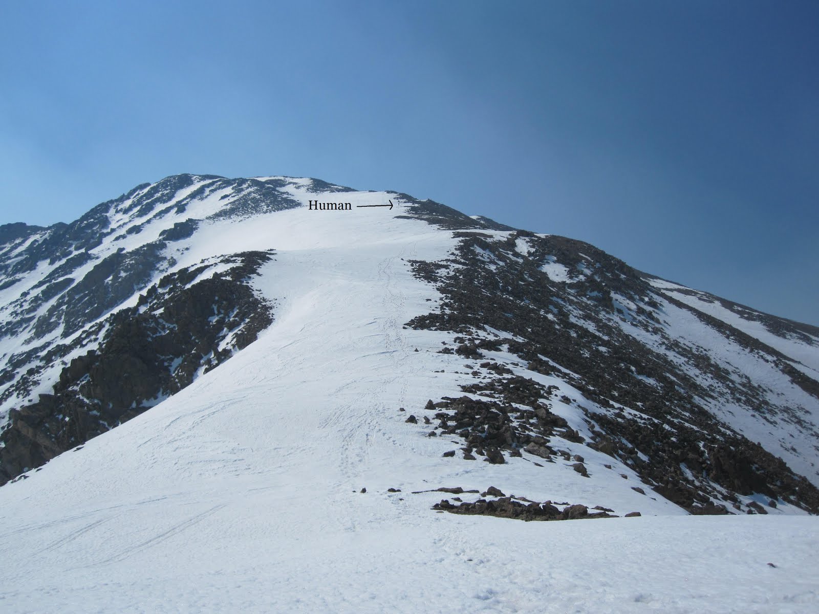
From here I rested briefly. I still had about 1600 vertical feet to go and it would be tough. Maybe 500 vertical feet up I looked on ahead of me and thought I saw movement. Turns out it was a human.
 |
| A little easier to see here. |
Hiking the ridge was exhausting and I kept looking at my altimeter to see my how far I had gone/have left. About 2 hours from the start of the ridge I was on the summit. I had full cell service so I updated my facebook status of course and called my wife to check in. I spent some time trying to work my auto-timer to get my summit photos. I got some good shots and bad ones.
Bad Ones:
 |
| At least I'm not blurry. |
 |
| At least my whole body is in the shot. |
 |
| Blurry and I missed the shot. |
So I lied about any good shots with the auto-timer. I just went with the old stick the arm out and shoot.
More Summit shots:
 |
| Mt. Elbert in the distance just left of center. |
I knew I'd be in for a slush fest during the descent so I didn't stay on top too long. I glissaded where I could though I was careful because I didn't have my axe to arrest myself with. The last glissade I did was a little crazy and I got going a bit fast. I was hoping that somewhere at the end of that glissade I would find the trail leading back. I stopped about 20 feet down from where I wanted to stop and looked to my right and beheld the clear and defined trail. How about that? I changed my socks as they were quite wet as well as my gloves. I finished the last of my fruit snacks and Gatorade and began the march through wet snow back to the car.
Yada yada yada it took a really long time to get back. Between finding the trail and postholing in the snow it was exhausting. It was heaven to reach the snowless trail below 10,600. From there it was an easy jaunt to the car.
One last look back on La Plata:
I've been bringing a full change of clothes with me now on these Spring hikes because I find that I get really wet. It feels nice not to have to drive home in the same clothes I just hiked 10 miles in. My last stop before home would be K's Old Fashioned Burgers in Buena Vista. Instead of giving you a number for your order they give you the name of a celebrity. That day I was Brad Pitt and I threw up in my mouth just a little.
Notes to Self:
- buy new gaiters.
- stop wasting time on trails that aren't the ones you came to hike
- fruit snacks are delicious while hiking
- fruit snacks are delicious always