Monday, June 6, 2011

La Plata Peak 6/4/2011

Total Mileage: ~10 miles
Total Elevation: ~4500 feet
Starting Point: La Plata Trailhead
Time: 9 hours start to finish
Party: solo

(click to enlarge photos)

La Plata Peak 14,336 feet
Another fun peak to check off the list. This would be my 20th 14er which only served as a reminder that I'm not even halfway through the list yet. I'm having a great time making my way towards my goal and each new peak provides a little bit different experience. La Plata trailhead is only about 30 miles from a little place called Aspen. Had there not been so much smoke in the air from the fires in CO and AZ I may have had some better views of the Elk mountain range that surrounds Aspen.

I knew from my research that there would be three creek or stream crossings in the first couple of miles. I try to piece together a little strategy by identifying landmarks and their distance from one another to distract myself from the physical toll my body takes. I can't really think about the strain in my legs if I'm trying to calculate the time it will take to get to point C after reaching point B if my speed is X. It's weird, I know. But it works. The rivers were rip-roaring more than usual due to the Spring runoff. The snow is melting quickly. I hit a little speed bump when I hit the trail registry and continued on the dirt road instead of the dirt trail. I must have been involved in a crazy math problem because I had gone about 1/2 mile and it just hit me that I had failed to start on the right trail.

The first two river crossing are on high bridges and are no cause for concern. The third was tricky because it was just logs with rushing water lapping over them. The water was higher than usual making the normal path very unappealing. Looking at the logs, I conjured up images of watermelon seeds on linoleum, and loony toon characters walking across banana peels. I couldn't bring myself to cross the logs fearing a slip into the water below. Upstream only about 20 feet I found a tree that was about 6-8 inches in diameter suspended across the stream about 18 inches in the air. It was dry and strong and easily made the stream passable. Next obstacle I knew would be snow. It would only be a matter of time before the trail became less and less visible and I would choose my own path through the snow to reach treeline.

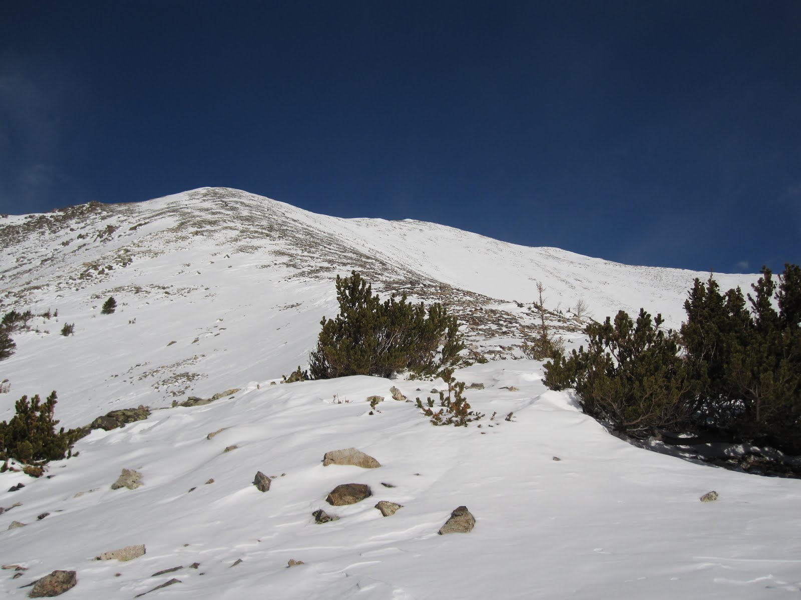
It happened around 10,600 feet. A little earlier than anticipated. The trail follows a stream until about 11,300 when the trail starts to gain more elevation and strays from the valley below into a gully that ascends rapidly. I decided that I would try to stay close to the stream and look for a good opportunity to bushwhack upwards. Every now and then a hint of a trail would appear from under a mound of snow only to disappear a few feet ahead into another mass of it. Enough for me to know I'm going the right way. I ascended earlier than I should have but it wasn't all that big of a deal. I would reconnect to the trail at around 11,600 and continue working my way to the NW ridge of La Plata Peak at 12,700. From the ridge it would just be straight up until you can't go up anymore. It took three hours to gain that ridge from the time I left the car. I had estimated less time but the snow drifts drained my energy fast early on.

Roughly shows my route out of the valley and towards the ridge.
Climbing a bit farther I could finally see my path to the ridge and much of the remaining route.


From the ridge the views were improving.

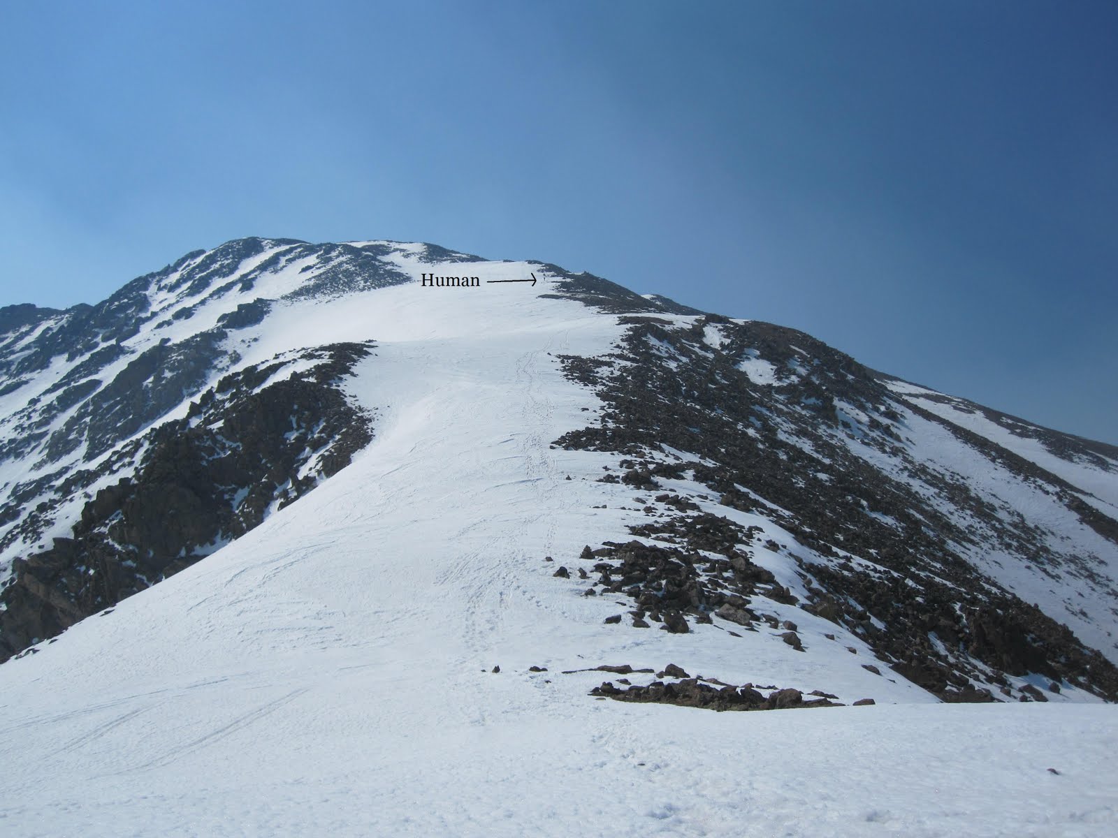
From 12,700 feet La Plata is visible but some of the route up is not. 
To the East from the same spot is Ellingwood Ridge which also leads to the summit. 
Cornices to watch out for.
From here I rested briefly. I still had about 1600 vertical feet to go and it would be tough. Maybe 500 vertical feet up I looked on ahead of me and thought I saw movement. Turns out it was a human.

A little easier to see here. 
Hiking the ridge was exhausting and I kept looking at my altimeter to see my how far I had gone/have left. About 2 hours from the start of the ridge I was on the summit. I had full cell service so I updated my facebook status of course and called my wife to check in. I spent some time trying to work my auto-timer to get my summit photos. I got some good shots and bad ones.

Bad Ones:

At least I'm not blurry.
At least my whole body is in the shot.
Blurry and I missed the shot. 
So I lied about any good shots with the auto-timer. I just went with the old stick the arm out and shoot.


More Summit shots:


Mt. Elbert in the distance just left of center. 
I knew I'd be in for a slush fest during the descent so I didn't stay on top too long. I glissaded where I could though I was careful because I didn't have my axe to arrest myself with. The last glissade I did was a little crazy and I got going a bit fast. I was hoping that somewhere at the end of that glissade I would find the trail leading back. I stopped about 20 feet down from where I wanted to stop and looked to my right and beheld the clear and defined trail. How about that? I changed my socks as they were quite wet as well as my gloves. I finished the last of my fruit snacks and Gatorade and began the march through wet snow back to the car.

Yada yada yada it took a really long time to get back. Between finding the trail and postholing in the snow it was exhausting. It was heaven to reach the snowless trail below 10,600. From there it was an easy jaunt to the car.

One last look back on La Plata:

I've been bringing a full change of clothes with me now on these Spring hikes because I find that I get really wet. It feels nice not to have to drive home in the same clothes I just hiked 10 miles in. My last stop before home would be K's Old Fashioned Burgers in Buena Vista. Instead of giving you a number for your order they give you the name of a celebrity. That day I was Brad Pitt and I threw up in my mouth just a little.


Notes to Self:
- buy new gaiters.
- stop wasting time on trails that aren't the ones you came to hike
- fruit snacks are delicious while hiking
- fruit snacks are delicious always

Sunday, May 29, 2011

Mount Antero 5/28/2011

Total Mileage: 15 miles
Total Elevation Gained: 5500 feet
Starting Point: Baldwin Gulch Trailhead
Party: Solo

(click to enlarge photos)


Picture taken at 12,700 feet.
 I ventured back to the southern Sawatch Range to tackle Mount Antero. While this mountain doesn't rate as anyone's favorite it did offer spectacular views and an all around great Saturday to kick off Memorial Day weekend. Knowing the route was 15 miles roundtrip might have been a deterrent 6 months ago. One thing I've come to learn about climbing is that mileage is virtually irrelevant. There have been numerous occasions where I've only had 1/4 of a mile to go and it's taken me an hour to cover that ground. The vertical increase is much more informative to me when describing a route. In fact, the last hike I did, Mt. Shavano, was half of the mileage and took me the same amount of time to complete. In researching this route, I knew it was full of switchbacks that very gradually sloped upward.

I got a 6 am start at the trailhead at around 9600 feet. In less than an hour I had covered 2.7 miles and 1200 vertical feet arriving at a stream crossing that I had been anticipating.


10,800 feet
 It's about one more mile until you exit the trees and start switching back up the mountain on a wide path. This mile was slow-going to say the least. I intentionally left my snowshoes in my car thinking of them as dead weight. As I continued forward I was fortunate to be hiking at an early hour. The snow accumulation on the trail leaves no other choice but to hike on top of it much of the way. At 7 am the snow pack was cold and hard and my weight would be supported only occasionally breaking through the hard outer crust and falling to my waist. Conditions worsened however, and at around 11,700 feet I saw a break in the trees and decided to alter my course slightly. Above me was a myriad of switchbacks and the path that I left would have soon led me there. Through the trees I looked up and saw a grassy mound that topped out a few hundred vertical feet from my position. That mound was free of snow and seemed much more inviting then the current path I was on where the post-holing had become much more frequent. Once above the mound I estimated that I would find myself on the standard path or close enough to it that an easy course correction would shortly get me there. I estimated correctly and within a short amount of time found myself at 12,600 feet and on the right track moving upwards. I had really nice views from that point so I grabbed some shots around me.


Looking SE  Mount Cronin 13,870 feet

East aspect of Mount Antero
 The next two shots I took a little further up at around 12,800 feet. They show Point 13,800 and the last long switchback that skirts around it.


Pt. 13,800 dead ahead and the start of the switchback that goes around it.

Skirting around this point is the path I followed up.
Pt. 13,800 is the next landmark of this route with the idea being to get on top of it. I ran into a few hikers later on that had described just going straight up this point and bypassing the route around. That's definitely one way to do it. I was able to witness these guys hiking up and over pt. 13,800 while I was on the summit.

Two hikers can be seen here cresting pt. 13,800. One is just about to crest and the other is behind a ways.
Close-up on hiker #1
I came around this point on the other side which offers a more gradual slope but is definitely longer. Once there, the remaining route is visible.

It's as easy as following a ridge from here.
 The rocky portion seen above provided great protection from a wind that was starting to pick up. The last 400 vertical feet were exceptionally difficult due to the relentless winds. Simple things that you never think about, like keeping your balance, become a very conscious task at high elevation and after expending so much energy. Every step and handhold becomes very deliberate and thought out.

Before too long but not soon enough I made the summit.

Vital stats.
Moun Antero summit 14,269 feet. Tabeguache can be seen to my left.
One thing I want to point out that you may notice is that my GPS says that I was moving for 3 hours and 33 minutes and stopped for 2 hours and 7 minutes. During the mile after the creek crossing there were times where I was going so slow that my GPS was calculating that time as stopped time or resting time when, ironically, that was the time where I was exerting myself the most. A little FYI for those thinking that I was sitting around for 2 hours of this trip.

One more from the top

Sawatch Mountain Range


On the way down I encountered a party of three that had separated from each other without knowing exactly where. With a bird's eye view from the summit I saw the whole thing unfold. Cresting point 13,800 the last of three to get there had a slightly different trajectory and while the first two waited for him he had already continued up the final ridge. Watching from the summit with binoculars I even saw one of the first two drop his pack and go back over the point looking for the third. Come to find out, the stray hiker had started alone and joined the party of two earlier in the day. Anyways, I spoke with all three on the way down and expressed how much I wish I could have yelled down to them what had happened. They were kind enough to snap a photo of me coming down.

Just below the final pitch.
I took a few shots of them with their camera and then a few more with mine after descending a bit more.

They're right about in the middle of the rocky ridge.
A little easier to see because they're crossing a small patch of snow.
A had planned on being open to the idea of a Mount Cronin summit as well. After descending back down to about 13,100 feet I really felt I could handle another 700 vertical feet up. I made my way over to the base of where I would start ascending. My GPS read that I had dropped to about 12,700 and I had not expected to drop that low. So now it was 1100 more vertical feet plus the 300 to get back to the Antero trail. One peak would have to suffice for the day. I would love to come back and climb Cronin in the future.

The descent was fairly quick. I went down the exact way I came up. There were a few areas where glissades were possible.

Always a fun way to descend.
Back under the cover of the trees conditions had deteriorated and post-holing was constant back down to the creek crossing at 10,800 feet. I stopped even trying to tiptoe on top of the slushy ice and just pounded through it. It definitely pounded back. It was a rough mile that made me long for the summer hikes that got me hooked on hiking in the first place. Back at the creek crossing I picked up a 20 oz bottle of Gatorade I had hidden behind a rock and started the last 2.7 miles back to my car.
Notes to self:
I enjoy watching the seasons come and go and being able to witness the changes in the landscape. Each season has its advantages and disadvantages. While post-holing can turn a dream hike into a nightmare quickly I will absolutely miss glissades and plunge-stepping my way off a mountain. And I suppose by the end of the summer I'll be looking forward to cooler temps and a rest for my knees.

Friday, May 6, 2011

Mount Shavano and Esprit Point 5/4/2011

Total Mileage: ~8 miles
Total Elevation: ~5500 feet
Starting Point: Angel of Shavano Trailhead
Group: solo

(click to enlarge photos)


I had been thinking of climbing another 14er and I had a few in mind. Weather, conditions, and an opportunity for a unique route led me to choose Shavano. My usual route finding research ensued. I consulted 14ers.com and Gerry Roaches Colorado's Fourteeners. I found a route description in Roach's book that was not found on 14ers.com and intrigue set in. The starting point was the Angel of Shavano trailhead and the first instruction in Roach's guidebook was "bushwhack .5 miles due north." This route is a snow only route due to the environmental damage that hiking would cause if there was no snow. The snow is melting fast on the mountains it seems so I decided on the "bushwhacking" snow route. This route would require the summit of a 13er called Esprit Point which would end up being the first 13er in Colorado I've climbed.

Roach's instructions were to stay North-Northwest maintaining a position between two drainages to the east and west. So it turned out that not having a trail wasn't any kind of disadvantage. There was really only way to go up. As the ridge steepened I began to switchback my way up the mountain. Here's the general route up (red) and down (green).

Shavano is barely visible and I'm 92% sure that Esprit is not visible here.
The way down involved a glissade that may have been more work than it actually saved me. I was making decent time when I hit treeline.

A look behind at the trees I just came from.
Mt Ouray to the Southeast
This is me thinking I'm much farther along than I really am.
The way up to the ridge that leads to Esprit Point.
I felt great coming out of the trees. I did feel like I was farther than I really was. Getting to that ridge I had views of Shavano and Esprit and I realized that I was not nearly as close as I thought I was. When became strong and unrelenting from the time I topped that ridge until the time I left it hours later. Every now and again I would find myself with a minute or so of relief and I hoped it would let up eventually. It didn't. This has been my experience hiking above 13,000 ft. The top of Esprit would signify 4500 feet of elevation gain over about 3 miles. It had taken about 5 hours. Another hour and twenty minutes later I was sitting on top of Shavano and I knew that I would be calling it a day. Tabeguache Peak (14,155 ft) was less than a mile away but the thought of re-summiting Shavano to get back seemed too much this day. I enjoyed myself on the summit for about 15 minutes and started the journey back to the car.

Mount Shavano viewed from 13,300 ft. Almost 1000 vertical feet to go.
Climbing up Shavano's last pitch looking back on Esprit Point.
Summit!
I'll to come back for this one.
Mount Ouray again.
The Sawatch range!
The way back was just like the way up. Except that instead of staying between the two drainages I got myself nestled in the east drainage and let the snow slide me right down. I probably descended about 2000 vertical feet in under 5 minutes. Great fun. I essentially followed the drainage right out and ended up back on County Road 240 which is the road I came in on. I missed the trailhead by about 300 yards. Found my way back to car around 3:30 pm making it about a 9.5 hour round trip.

A look up the drainage well below snow level.
Last look at Shavano and Esprit before heading home.

I wish I could've tackled Tabeguache as well but a time commitment left me pressed to get home. I'm excited for summer to arrive to be able to hit these mountains without snow and with full access to the trailheads. I've loved hiking in the winter and spring but each season has it's own element of excitement that it brings.

Notes to Self:
-weigh my pack before leaving next time (I'm curious as to how much weight is on my back)
-be thorough with sunscreen (the under part of my nose got it bad, but that's it)

Monday, April 18, 2011

Mount Belford 4/6/2011

Total Mileage: ~16 miles
Total Elevation: ~5000 ft.
Starting Point: 4 miles below the Missouri Gulch Trailhead
Group: Solo
(click to enlarge photos)


I had large aspirations when this day started. When it ended, I was glad to not be spending the night in my car out of necessity. I had awoken very early to get a good start on this hike. I had figured that the trailhead was not going to be accessible from the recent reports I had read. I wanted to get as close to the TH as I could. As it would turn out, I was a bit over zealous in my car's abilities and started my day stuck in the snow pretty deep about 4 miles from the TH. It was 5:30am and it was still dark. I spent 30 minutes digging my car out with my ice axe to no avail. At about 6 am I convinced myself to proceed with the hike and get my car out later.

The original plan was to climb Mount Belford first, then traverse over to Oxford and at that point evaluate conditions with hopes of climbing Missouri Mountain as well. From the get-go I knew that Missouri would not happen. Not with the added time it was now going to take me to get my car unstuck after my hike. I was still optimistic and thought that today was going to be a two mountain minimum. It was an uneventful 4 mile start to the beginning of the Missouri Gulch TH.


I cached one bottle of Gatorade and one bottle of water here at the TH knowing I wouldn't need it until later. The beginning of the trail starts getting steep right away as it weaves it's way up through the forest. I wore only my hiking boots because the snow was just soft enough for good purchasing but not too soft that I would fall though it. I had Microspikes and snowshoes with me that I would use later on. On the descent of this same section of trail I would find that even with snowshoes on I was sinking 6-8 inches with every step. The warm afternoon made the snow very squishy.

Before I emerged from the trees the snow began to give way and the postholing commenced. I strapped on my snowshoes and continued upward and onward. While reviewing the route for this hike I remember reading about a stream crossing followed by an old abandoned log cabin along the trail. I thought it strange at many points up the trail that I had not passed this area. I never saw the log cabin on the way up or the way down. I have an inkling as to where I missed the trail but it will be fun to return here this summer and see where I went off. Directionally, I knew where I had to go so route finding was not difficult in spite of losing the trail. Snowshoes proved to be quite useful. A tough slog through the remaining forested area and I was out in the open.

A look behind.

Belford dead ahead

Looking at hiker's left.
Two strikes against me now. Getting the car stuck and losing the trail. I didn't think much of it though because I had already decided that not doing Missouri would save me oodles of time. With Belford in sight it was straight ahead to the part that I had been dreading. The shoulder up Belford leading to the summit. Mount Belford is not rated as a very difficult mountain to climb however, the final one mile to the top covers 2300' of elevation. It is long, it is relentless, it is never-ending, and it is tough. In addition to this I had been feeling especially weak all morning long. I can only attribute this to simply having an "off" day. I cached the snowshoes at the bottom of the shoulder and began my ascent up. It took me 2.5 hours to climb that shoulder. I felt the need to stop very frequently to catch my breath. When I was moving it was not much faster than a crawl. I made to the top of the shoulder which put me just below the summit of Belford. Reaching this saddle I had great views of many beautiful mountains surrounding the area. Contrasted with the dreary view of the remaining route.

The way up (summit not visible)
Before too long I was on top and looking at a lot of familiar peaks.


It was around 2ish when I made the summit and I was disgusted at such awful time I had made getting there. I knew there was no way Oxford was in the cards that day. Also, the summit pictures when compared to the pictures in the open basin show a very different weather forecast. I was happy to have one more mountain under my belt and decided to claim it as a victory and head home. I glissaded most of the way down and was down the shoulder in about 14 minutes. I fetched my snowshoes and headed back down trying to see if I could find the trail on the way down. Before that I ran into these sneaky buggars.

Discovered in the late 1700's these strange birds are thought by scholars to be some kind of hybrid of the native warblers and mountain chickens. They are also bred for their skills and magic.

I searched long and hard for any semblance of a trail and came up empty handed. I went down slightly deviating from the way I had come up. I found no trail but instead a tree that looked like it had no place being where it was.

Either a sycamore or a maple spruce. Or any number of other possibilities.
I ended up being able to swing back a bit to find my tracks up. I followed them down to where the trail clearly picked back up and looked around very confused at where I had gone amiss. I shrugged my shoulders (I literally did this) and decided that I'd find out this summer the answers to my questions. I was back to the TH in no time and picked up my stashed liquids and headed down to the next big task ahead of me. I told myself I'd try for 45 minutes and then If I wasn't successful getting my car out I'd call a towing service. This is how my day ended.


I drove out around 7ish and still had a bit more daylight left. I stopped in Buena Vista for a burger and headed back to CO Springs.

Notes to Self:
- Snowshoes aren't the devil after all
- trails are for suckers
- cell phone coverage saved my butt so I should probably switch to Verizon if I'm going to continue hiking.