Sunday, August 28, 2011

Mount Lindsay 7/5/2011

Total Mileage: 8 miles
Elevation Gain: 3500 feet
Starting Location: Lily Lakes TH
Time: 6 hours 20 minutes
Party: Solo


I've fallen behind in my archiving 14er summits. Early in July I climbed Mount Lindsay located in the Sangre de Cristo mountain range. It was a beautiful day and the weather held out the entire time. The Lily Lakes trailhead requires quite a journey to arrive. The last 20 miles or so is on a dirt road and takes about one hour to drive. Right before I hit the dirt road I hit a bunny rabbit while driving about 70 mph. It slightly dislodged my already damaged bumper and I had to thread a plastic bag through the holes in the bumper liner to temporarily reattach it. Eventually I arrived at the trailhead.

Lily Lakes Trailhead
I got all my stuff together and after about 4 minutes of hiking I was treated to this:

Tremendously scenic day right off the bat.
The first portion of this hike takes you up through a gulch right along side a babbling brook.


A closer look at the cave seen in the last picture. At least 6 US presidents are believed to be buried here.
Up through the gulch I reached a large basin that I would meander across to begin the real climbing of the day. At the start of the basin I caught my first glimpse of Mount Lindsay.

Mt. Lindsay dead center and the basin I would cross and climb out of. 
From the same spot I could see two 14ers looking to my right. Blanca Peak and Ellingwood Point.

Add caption
It seemed as I got closer that Mount Lindsay looked taller.

Looking from about halfway to the saddle above the basin. 

Out of the basin, on the saddle with the rest of my route in view. 
The next picture is actually on the way down but shows the steepness and some perspective of the remaining route up. There are people above me who are being very careful not to kick rocks down on me.


There were a few loose spots, a few steep spots, a few breaks for water, and a few minutes later I was standing on the summit of Mount Lindsay.

14,042 feet! 
Liitle Bear Peak, Blanca Peak and Ellingwood point all visible. All are above 14000 feet themselves as well
I stayed on top for about 20-30 minutes and made my way down snagging one last photo before heading back down the basin following the gulch back out.

These are my wife's favorite pair of sunglasses I own. She says they make me look really cool.

Pretty uneventful hike down. This was by far one of the more scenic mountains I have ever climbed. I am writing this about 2 months after hiking it so I don't remember a lot of details. Definitely one that I would do again.

Notes to self:
-When writing about killing bunnies remember to post pictures
- bring helmet
- never lose these sunglasses

Tuesday, June 14, 2011

Mount Elbert 6/10/2011

Total Mileage: 9 miles
Total elevation Gain: ~4700 feet
Starting Point Mt. Elbert Trailhead
Time: 6.5 hours
Party: Solo

(click to enlarge)


While Mount Elbert is considered one of the easier 14ers to climb in Colorado it also takes the prize of the tallest. It is also the tallest peak in the Rocky Mountains and 2nd tallest peak in the lower 48 states. I had a perfect weather window and the day off from work to go climb this awesome peak.

I expected a lot of traffic on the trail but was not disappointed when I found very little. With record snowpack still on many of the mountains this may be a deterrent for the normal traffic that would be expected on Mount Elbert in June. The trail was clear except for the last 1/2 mile before treeline where mounds of snow turned into walls of snow.

Very distinct trail where it is clear of snow. Perhaps only surpassed by the Barr Trail on Pikes Peak.
Emerging from the trees.
The snowpack that still covers the trail right before treeline. 
Taken from the same spot this shows the route ahead. The summit is blocked from view here.
 With the trees and snow behind me the rest of the hike was straight forward. Just keep going up on the clear trail. Although clear and unavoidable I don't think it's a trail to be taken lightly. It does get quite steep at times and there are about three major false summits for your demoralizing pleasure.

The first of the false summits to come. Path actually curves around to the right at the top.
Mount Massive to the north taken at around 13000 feet. 
A lot of these guys bustling around the mountain. They're pretty brazen at times. 
Fruit snacks have become my constant companion on my hiking adventures now. I feel the cherry and peach flavors coursing through my veins giving me the energy to put one foot in front of the other. Before too long I reached the top of the final false summit to see the real summit of Mount Elbert a few hundred yards off.

The final push to the end.
I reached the top just as two skiers were getting ready to drop down. I troubled them for a couple pictures before they left. After that I had the summit to myself (not common on Elbert) for about 20 minutes.

Elk Mountain Range behind me.
La Plata Peak dead center. I climbed that one the previous week.
Sawatch Range to the south. 
Mount Massive to the North (pictured earlier at lower elevation)
Twin Lakes just south. 
La Plata Peak again right below my right ear.
I headed down and the descent went by very quickly. I tend to put my head down a lot when descending to ensure my footing and nearly walked right on top of this guy.

No way he's moving.
Within an hour I was back to the trees and snow and ended up getting a bit lost. My GPS had lost battery power so I had to just backtrack a bit and eventually I connected with the path down.

The path disappears under the snow right when you enter the cover of the trees. 
It took 3 hours and 45 minutes to summit and an hour less to descend back to the car. Total time of 6.5 hours which was pretty decent timing for me. I consider myself slightly less than average speed going uphill and faster than average going down.

This would be a new elevation record for me which I don't plan on braking for a while. A Mt. Kilimanjaro trip may be in the works for September 2012. Until then , 14,433 feet will stand as my p.r. Every hike this last month has excited me for the summer hiking to come.

One last parting picture.


Notes to Self:
-Keep batteries in my car or backpack
-Buy a Jeep Rubicon
-Be better at life

Monday, June 6, 2011

La Plata Peak 6/4/2011

Total Mileage: ~10 miles
Total Elevation: ~4500 feet
Starting Point: La Plata Trailhead
Time: 9 hours start to finish
Party: solo

(click to enlarge photos)

La Plata Peak 14,336 feet
Another fun peak to check off the list. This would be my 20th 14er which only served as a reminder that I'm not even halfway through the list yet. I'm having a great time making my way towards my goal and each new peak provides a little bit different experience. La Plata trailhead is only about 30 miles from a little place called Aspen. Had there not been so much smoke in the air from the fires in CO and AZ I may have had some better views of the Elk mountain range that surrounds Aspen.

I knew from my research that there would be three creek or stream crossings in the first couple of miles. I try to piece together a little strategy by identifying landmarks and their distance from one another to distract myself from the physical toll my body takes. I can't really think about the strain in my legs if I'm trying to calculate the time it will take to get to point C after reaching point B if my speed is X. It's weird, I know. But it works. The rivers were rip-roaring more than usual due to the Spring runoff. The snow is melting quickly. I hit a little speed bump when I hit the trail registry and continued on the dirt road instead of the dirt trail. I must have been involved in a crazy math problem because I had gone about 1/2 mile and it just hit me that I had failed to start on the right trail.

The first two river crossing are on high bridges and are no cause for concern. The third was tricky because it was just logs with rushing water lapping over them. The water was higher than usual making the normal path very unappealing. Looking at the logs, I conjured up images of watermelon seeds on linoleum, and loony toon characters walking across banana peels. I couldn't bring myself to cross the logs fearing a slip into the water below. Upstream only about 20 feet I found a tree that was about 6-8 inches in diameter suspended across the stream about 18 inches in the air. It was dry and strong and easily made the stream passable. Next obstacle I knew would be snow. It would only be a matter of time before the trail became less and less visible and I would choose my own path through the snow to reach treeline.

It happened around 10,600 feet. A little earlier than anticipated. The trail follows a stream until about 11,300 when the trail starts to gain more elevation and strays from the valley below into a gully that ascends rapidly. I decided that I would try to stay close to the stream and look for a good opportunity to bushwhack upwards. Every now and then a hint of a trail would appear from under a mound of snow only to disappear a few feet ahead into another mass of it. Enough for me to know I'm going the right way. I ascended earlier than I should have but it wasn't all that big of a deal. I would reconnect to the trail at around 11,600 and continue working my way to the NW ridge of La Plata Peak at 12,700. From the ridge it would just be straight up until you can't go up anymore. It took three hours to gain that ridge from the time I left the car. I had estimated less time but the snow drifts drained my energy fast early on.

Roughly shows my route out of the valley and towards the ridge.
Climbing a bit farther I could finally see my path to the ridge and much of the remaining route.


From the ridge the views were improving.

From 12,700 feet La Plata is visible but some of the route up is not. 
To the East from the same spot is Ellingwood Ridge which also leads to the summit. 
Cornices to watch out for.
From here I rested briefly. I still had about 1600 vertical feet to go and it would be tough. Maybe 500 vertical feet up I looked on ahead of me and thought I saw movement. Turns out it was a human.

A little easier to see here. 
Hiking the ridge was exhausting and I kept looking at my altimeter to see my how far I had gone/have left. About 2 hours from the start of the ridge I was on the summit. I had full cell service so I updated my facebook status of course and called my wife to check in. I spent some time trying to work my auto-timer to get my summit photos. I got some good shots and bad ones.

Bad Ones:

At least I'm not blurry.
At least my whole body is in the shot.
Blurry and I missed the shot. 
So I lied about any good shots with the auto-timer. I just went with the old stick the arm out and shoot.


More Summit shots:


Mt. Elbert in the distance just left of center. 
I knew I'd be in for a slush fest during the descent so I didn't stay on top too long. I glissaded where I could though I was careful because I didn't have my axe to arrest myself with. The last glissade I did was a little crazy and I got going a bit fast. I was hoping that somewhere at the end of that glissade I would find the trail leading back. I stopped about 20 feet down from where I wanted to stop and looked to my right and beheld the clear and defined trail. How about that? I changed my socks as they were quite wet as well as my gloves. I finished the last of my fruit snacks and Gatorade and began the march through wet snow back to the car.

Yada yada yada it took a really long time to get back. Between finding the trail and postholing in the snow it was exhausting. It was heaven to reach the snowless trail below 10,600. From there it was an easy jaunt to the car.

One last look back on La Plata:

I've been bringing a full change of clothes with me now on these Spring hikes because I find that I get really wet. It feels nice not to have to drive home in the same clothes I just hiked 10 miles in. My last stop before home would be K's Old Fashioned Burgers in Buena Vista. Instead of giving you a number for your order they give you the name of a celebrity. That day I was Brad Pitt and I threw up in my mouth just a little.


Notes to Self:
- buy new gaiters.
- stop wasting time on trails that aren't the ones you came to hike
- fruit snacks are delicious while hiking
- fruit snacks are delicious always

Sunday, May 29, 2011

Mount Antero 5/28/2011

Total Mileage: 15 miles
Total Elevation Gained: 5500 feet
Starting Point: Baldwin Gulch Trailhead
Party: Solo

(click to enlarge photos)


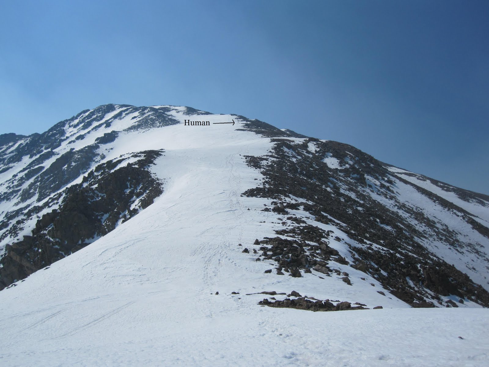
Picture taken at 12,700 feet.
 I ventured back to the southern Sawatch Range to tackle Mount Antero. While this mountain doesn't rate as anyone's favorite it did offer spectacular views and an all around great Saturday to kick off Memorial Day weekend. Knowing the route was 15 miles roundtrip might have been a deterrent 6 months ago. One thing I've come to learn about climbing is that mileage is virtually irrelevant. There have been numerous occasions where I've only had 1/4 of a mile to go and it's taken me an hour to cover that ground. The vertical increase is much more informative to me when describing a route. In fact, the last hike I did, Mt. Shavano, was half of the mileage and took me the same amount of time to complete. In researching this route, I knew it was full of switchbacks that very gradually sloped upward.

I got a 6 am start at the trailhead at around 9600 feet. In less than an hour I had covered 2.7 miles and 1200 vertical feet arriving at a stream crossing that I had been anticipating.


10,800 feet
 It's about one more mile until you exit the trees and start switching back up the mountain on a wide path. This mile was slow-going to say the least. I intentionally left my snowshoes in my car thinking of them as dead weight. As I continued forward I was fortunate to be hiking at an early hour. The snow accumulation on the trail leaves no other choice but to hike on top of it much of the way. At 7 am the snow pack was cold and hard and my weight would be supported only occasionally breaking through the hard outer crust and falling to my waist. Conditions worsened however, and at around 11,700 feet I saw a break in the trees and decided to alter my course slightly. Above me was a myriad of switchbacks and the path that I left would have soon led me there. Through the trees I looked up and saw a grassy mound that topped out a few hundred vertical feet from my position. That mound was free of snow and seemed much more inviting then the current path I was on where the post-holing had become much more frequent. Once above the mound I estimated that I would find myself on the standard path or close enough to it that an easy course correction would shortly get me there. I estimated correctly and within a short amount of time found myself at 12,600 feet and on the right track moving upwards. I had really nice views from that point so I grabbed some shots around me.


Looking SE  Mount Cronin 13,870 feet

East aspect of Mount Antero
 The next two shots I took a little further up at around 12,800 feet. They show Point 13,800 and the last long switchback that skirts around it.


Pt. 13,800 dead ahead and the start of the switchback that goes around it.

Skirting around this point is the path I followed up.
Pt. 13,800 is the next landmark of this route with the idea being to get on top of it. I ran into a few hikers later on that had described just going straight up this point and bypassing the route around. That's definitely one way to do it. I was able to witness these guys hiking up and over pt. 13,800 while I was on the summit.

Two hikers can be seen here cresting pt. 13,800. One is just about to crest and the other is behind a ways.
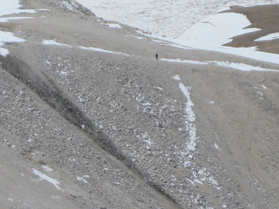
Close-up on hiker #1
I came around this point on the other side which offers a more gradual slope but is definitely longer. Once there, the remaining route is visible.

It's as easy as following a ridge from here.
 The rocky portion seen above provided great protection from a wind that was starting to pick up. The last 400 vertical feet were exceptionally difficult due to the relentless winds. Simple things that you never think about, like keeping your balance, become a very conscious task at high elevation and after expending so much energy. Every step and handhold becomes very deliberate and thought out.

Before too long but not soon enough I made the summit.

Vital stats.
Moun Antero summit 14,269 feet. Tabeguache can be seen to my left.
One thing I want to point out that you may notice is that my GPS says that I was moving for 3 hours and 33 minutes and stopped for 2 hours and 7 minutes. During the mile after the creek crossing there were times where I was going so slow that my GPS was calculating that time as stopped time or resting time when, ironically, that was the time where I was exerting myself the most. A little FYI for those thinking that I was sitting around for 2 hours of this trip.

One more from the top

Sawatch Mountain Range


On the way down I encountered a party of three that had separated from each other without knowing exactly where. With a bird's eye view from the summit I saw the whole thing unfold. Cresting point 13,800 the last of three to get there had a slightly different trajectory and while the first two waited for him he had already continued up the final ridge. Watching from the summit with binoculars I even saw one of the first two drop his pack and go back over the point looking for the third. Come to find out, the stray hiker had started alone and joined the party of two earlier in the day. Anyways, I spoke with all three on the way down and expressed how much I wish I could have yelled down to them what had happened. They were kind enough to snap a photo of me coming down.

Just below the final pitch.
I took a few shots of them with their camera and then a few more with mine after descending a bit more.

They're right about in the middle of the rocky ridge.
A little easier to see because they're crossing a small patch of snow.
A had planned on being open to the idea of a Mount Cronin summit as well. After descending back down to about 13,100 feet I really felt I could handle another 700 vertical feet up. I made my way over to the base of where I would start ascending. My GPS read that I had dropped to about 12,700 and I had not expected to drop that low. So now it was 1100 more vertical feet plus the 300 to get back to the Antero trail. One peak would have to suffice for the day. I would love to come back and climb Cronin in the future.

The descent was fairly quick. I went down the exact way I came up. There were a few areas where glissades were possible.

Always a fun way to descend.
Back under the cover of the trees conditions had deteriorated and post-holing was constant back down to the creek crossing at 10,800 feet. I stopped even trying to tiptoe on top of the slushy ice and just pounded through it. It definitely pounded back. It was a rough mile that made me long for the summer hikes that got me hooked on hiking in the first place. Back at the creek crossing I picked up a 20 oz bottle of Gatorade I had hidden behind a rock and started the last 2.7 miles back to my car.
Notes to self:
I enjoy watching the seasons come and go and being able to witness the changes in the landscape. Each season has its advantages and disadvantages. While post-holing can turn a dream hike into a nightmare quickly I will absolutely miss glissades and plunge-stepping my way off a mountain. And I suppose by the end of the summer I'll be looking forward to cooler temps and a rest for my knees.