Sunday, December 25, 2011

Mount Belford and Mount Oxford 12/21/2011

Total Mileage: ~10 miles
Total Elevation gained: ~5800 feet
Party: myself, Eric W.
Starting Point: Missouri Gulch TH

I climbed Mount Belford back in April of this year. I didn't want to hike it again but getting on top of Mount Oxford basically necessitates going up and over Belford. I knew that the trailhead was accessible (rare in winter). I also had a willing partner so it made sense to make this happen. I have bad memories of climbing Belford last April. It was quite difficult, I was sick, and on top of that I had got my car stuck in the snow trying to get closer to the trailhead. So when I reached the summit of Belford last time I was tired and sick, and I knew there was a chance I would need to call someone to tow my car out of the snow before places closed for the day. So I turned around and left Oxford for another day. This day.

It was 4 degrees when we started off at 6:30 am. We started off a bit cold but it quickly dissipated as we started to climb the initial switchbacks. I try to hike slow enough not to sweat but fast enough to keep good time. As we climbed past the trees we decided to cache our snowshoes at an old abandoned log cabin. There was a good snow trench that outlined the trail very well and we felt that snowshoes just weren't going to be needed today. We made good time to treeline and to the base of the Belford shoulder. I hate the Belofrd shoulder. It is about a mile long and 2200 feet tall. It is the standard route to the top of Belford. Last time I hiked it it took me 2.5 hours to climb just the shoulder and I felt like I was eking through every step.This time it took us 4.5 hours to climb officially making it my alpine nemesis.

Approaching the base of the shoulder. Pictures just can't do justice sometimes.

Looking back. The day was full of flashes of blue sky and thin wispy dark clouds.

Eric climbing the shoulder. 

Spotted this little pervert spying on us.
The shoulder was carrying about 4-5 inches of sugary snow on top of a layer of hard packed snow that was more like ice in some places. We were both stopping frequently and had no idea it was taking us so long to progress forward. When it donned on us how we were making such awful time we were confused as to why. We weren't in the best shapes of our lives but we weren't in bad shape either. The cold may have had something to do with it. We also may have unknowingly entered some kind of alpine vortex that sucks all your energy. Who knows....

Anyways....we made it to the top.
Nice and foggy on top with no views of anything. It was quite chilly.

I told Eric that there was no way I'm not getting Oxford today. He agreed and off we went. We had only spent about 10 minutes on the summit. We couldn't even see Oxford until right when we started off. I could see Eric's will deflate a bit when he actually saw the route. I tried to console him by explaining "it's always closer than it looks. We'll be there in 45 minutes for sure." So 90 minutes later we would be standing on top of Oxford looking forward to climbing back over Belford for our final descent.

Sitting just above the saddle between Belford and Oxford.

Mount Belford is the tiny bump in the center. 14,197 feet.

The remaining route to Mount Oxford.

Summit of Oxford (14,153 feet) with Mount Harvard (14,420 feet) in the background.
 We knew we would be hiking home in the dark. We weren't terribly concerned about that because we were prepared for that. I think most people descend via Elkhead Pass which is a different route down than we took up. Neither of us were familiar with that route so we decided to go back over Belford and descend the exact way way we came up the mountain. It really didn't add much more elevation gain to our trip but it made us feel comfortable to know we wouldn't be doing any route finding in the dark. We didn't even stop on Mount Belford when we arrived the second time. It was cloudy and dark and we rolled over the summit like any other hill that day. By this time it was very, very cold. I thought that descending the shoulder would be a welcome respite from the non-stop climbing we had grown accustomed to. Turns out the shoulder sucked going down just as much as going up. It just didn't take as long.

The problem going down was that I didn't have trekking poles with me or an ice axe. So my ability to arrest myself was limited. I left my poles in the car because I felt like they make my hands colder. I didn't even bring my ice axe with me. So glissading was out of the question. It was too steep and too icy underneath. Plunge-stepping was a bad idea as well just because there wasn't enough snow for it. We just had to be careful and go slowly. Sometime while descending the shoulder I decided to pull out my headlamp. Eric had his on and I was sick of sharing the light. I had waited so long because I knew my headlamp was still in the packagin and I didn't want to mess with it. So when we stopped to drink I took off my gloves and scurried to get it my headlamp out. What I didn't know was that the batteries that came with the light were not pre-installed but were sitting in the packaging individually. In my haste to open the light all the contents burst into the air like a bag of chips. I sifted through the snow and found two of the three batteries required to operate the light. After 60 seconds of continued sifting I relented and told Eric I was glad he had brought his light because I would be sharing it with him. Once down the shoulder it was all pretty easy and a bit warmer as well. We found our snowshoes easily and strapped them back on and headed down the rest of the mountain. We made one quick stop in Buena Vista to get back some calories we had spent and we called it a day. A fourteen hour day...

Oh yeah...also, it's a good idea to clip toenails before hiking for 14 hours. Or this happens:

Apologies to my wife who told me not to post this photo.

Wetterhorn Peak and Uncompahgre Peak 10/16/2011

Total Mileage: ~14 miles
Total Elevation Gained: ~5500 feet
Party: solo
Total Time: 12.5 hours
Start Location: Nellie Creek TH

We were getting the interior of our house painted and my wife decided she didn't want to be around for it. So she left to visit her parents in Las Vegas with my 2 year old daughter. Wanting to make the most of my bachelor status I planned to get a few 14ers checked off my list while the wife was away. So after work (in Pueblo, CO) I drove to the town of Lake City, CO and enjoyed a quiet meal at a quiet restaurant. From there, the trailhead was about 12 miles away and that's where I spent the night while laying inside my wife's Toyota Highlander. I awoke at around 4:30 am and was on the trail by 5 sharp.

There was light snow. I didn't wear gaiters or microspikes and certainly didn't bring or use snowshoes. Gaiters and spikes could have been useful but weren't necessary. As I started out it was dark and it was cold. I had underestimated how long I would hiking in the dark. The sun didn't show up until about 7:30 am and by then I had made it to about 13K feet already. My hands were so cold I had to stop hiking and use my secret hand-warming method before continuing. It was a beautiful sight when the sun finally came over the distant range. It began to get warmer immediately.

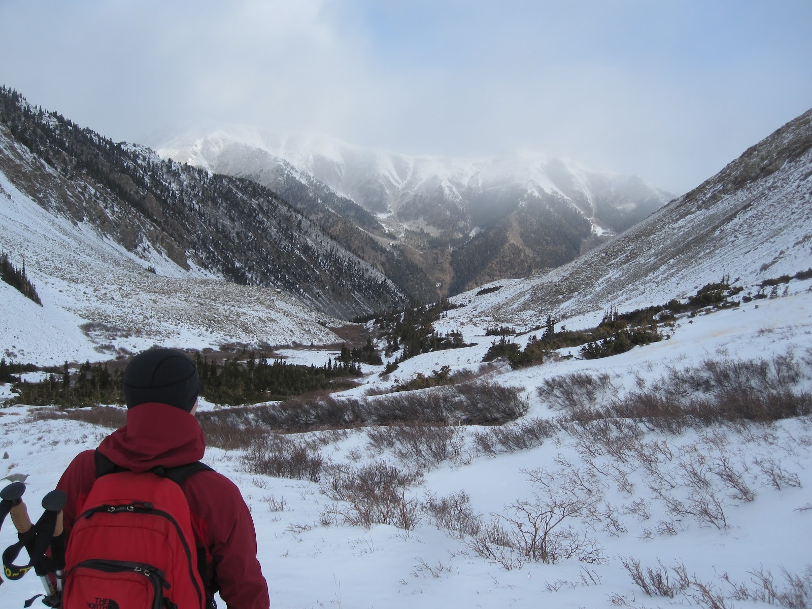
From my limited research, these two peaks are not always done together. It seems that, more often than not, there are hiked individually. I was very glad to find trip reports from those who have gone before me from 14ers.com. My first goal was reaching the summit of Wetterhorn Peak via the standard route. The hike up this route is very scenic and I would have taken more pictures if there would have been  more light available.

Wetterhorn Peak taken from about 13K feet just as the sun had risen. 

Uncompahgre Peak from essentially the same spot as above. This would be my second goal that day. 

The remaining 1000 vertical feet to the top of Wetterhorn was a lot of fun. I left my poles at 13K feet because I felt like gripping my poles was preventing my hands from staying warm. There is a prominent feature of Wetterhorn Peak that is commonly referred to as "The Prow" or "The Ship's Prow". It is visible in the first picture above as a small notch just left of the obvious summit. The route to the top passes right at the base of this impressive rock feature.

Passing below the Ship's Prow with the summit dead ahead.

The last couple hundred feet offers some fun Class 3 scrambling before topping off on the summit.

Standing on the summit (14,015 feet) with Matterhorn Peak and Uncompahgre Peak in the distance. 

More summit shots

The San Juan mountain range.

Proof that I was there.
From the top of Wetterhorn my next goal was the top of Uncompahgre Peak. When the sun came out the snow that was on the ground became a bit softer. I had to descend to about 12,400 feet before beginning to ascend again. I would be aiming for a notch that is very visible in the above pictures on Uncompahgre.

Same picture as above with the notch labeled that I'm referring to. 
There was a lot of meandering in the snow meadows below this notch. In fact, I had not originally planned to ascend that way but I was so sick of sinking in the snow that I felt justified in making a detour up the long scree slide just below that notch.

Finally made it to the base of the notch.
 It was a lot of hard work at this point in the day to climb that scree field. It was preferable however to walking in snow. It took about an hour and I was at the top of that notch which put me at about 13,300 feet if I remember right. Just another 1000 vertical feet to the top of Uncompahgre. It went by quick and before I knew it I was there.
Matterhorn peak is the one that is closest and Wetterhorn is behind it. Weird to think I was just there about 4 hours earlier. 

If there's one thing I'm good at, it's posing for pictures.

Summit shots

More summit shots.
 I was not looking forward to slogging through all that snow again. But I went down the way I came and I was fortunate enough to have my own footsteps to walk into to minimize the postholing.

Heading home.

This is Matterhorn peak from about 11K feet. About 2 miles from the trailhead. 
About 3 hours would pass before I found myself back at the car.My plan was to bag these two peaks and drive to Ouray, CO where I would climb Mt. Sneffels the following day. Truth is, I was too tired from this adventure and I really just wanted a bed to sleep in that night. So I started my car and made the trip back to Colorado Springs that night stopping to pig out at least twice at fast food joints along the way. In an unfortunate twist of fate, I arrived home and my bed had been plastic wrapped by the painters along with all my furniture and belongings. I had to sleep in the spare bedroom downstairs that wasn't being painted. Waking up the next morning I was quite content to be lounging around doing nothing instead of hiking another 14,000 foot mountain. Mt. Sneffels isn't going anywhere.