Wednesday, November 3, 2010

Humboldt Peak 11/1/2010

Total Mileage: 12.25 miles
Elevation gained: 4200 feet
Staring point: South Colony Lakes Trailhead (upper)

This picture was taken from 14ers.com and shows roughly the route I took.


I set out for the town of Westcliffe, CO at about 4:30am on Monday morning. The trailhead is about 10 miles from Westcliffe and I got there at about 6:55am. I had to wait until about 7:20 to get started because it was still too dark to get going when I got there. ( I should get a headlamp.) The dirt road to the trailhead was free of snow and it was pretty simple getting my Suburu Impreza wagon to the upper trailhead. I was alone on this hike and I probably will insist on company for any further winter hikes I participate in. I never felt unsafe, it just would have been nice to have some distraction from the cold. The thermometer keychain I keep on my backpack said 18 degrees Farenheit when I left. By the time I reached the summit at about 11:20am it had warmed up to about 30 degrees.

The first 3 miles of trail is the old 4WD road to the old trailhead. Pretty uneventful really. As I got higher and higher in elevation on this road there began to be little patches of snow and ice on the trial. Pretty soon I found myself walking on sheets of packed snow and ice. Coming down this road later in the afternoon when it warmed up a bit was a little tricky. I kind of had to hike in the brush alongside the trail to avoid the slippery patches of ice. Sometimes little stones about the size of my shoe or smaller would poke up out of the snow and provide stepping stones for me to avoid the ice patches. There were a couple of cool small waterfalls that had neat ice formations around them.


I didn't take a lot of pictures on this hike because I didn't want to stop and take off my gloves and risk getting too cold. I realized during the first few water breaks that I was getting significantly colder sitting down for too long. Keeping active and moving helped me a lot on this hike.

So I got to a point where the trail splits off the 4WD road and onto a real trail that dives into the trees. With about 5-6 inches of hard packed snow on the ground the trail came and went it seemed. I got to a point where I had stopped and looked 360 degrees and realized there was no trail in front or behind me. It made me laugh a little so I took a picture.


I knew from my map that I would run into the South Colony Lakes if I just headed north from where I was. I took out my compass, found north and starting blazing through the forest. After about 7-8 minutes of that I hooked back onto the trail and continued upward. Before too long I was at the lakes and began the trek up to the saddle between Humboldt and the Crestones. Right at about that point the fog lifted and I got a good shot of Crestone Needle.


One of the more impressive 14ers in all Colorado in my opinion. I plan on climbing the Crestones next spring or early summer. I was in a hurry to take this picture because you never know if a good view will become available again. It began to snow about then, and it got really foggy again. The wind picked up when I hit the saddle and I got really cold really fast. The ridge from the saddle to the summit of Humboldt runs roughly east/west so I stayed on the south portion of the ridge and that provided a good deal of protection from the wind that seemed to be coming from the north. Halfway up the ridge the fog lifted, the wind died down and I saw great views of everything all around me. I was at the false summit before I knew it and snapped a quick shot of the final 1/4 mile up the ridge.


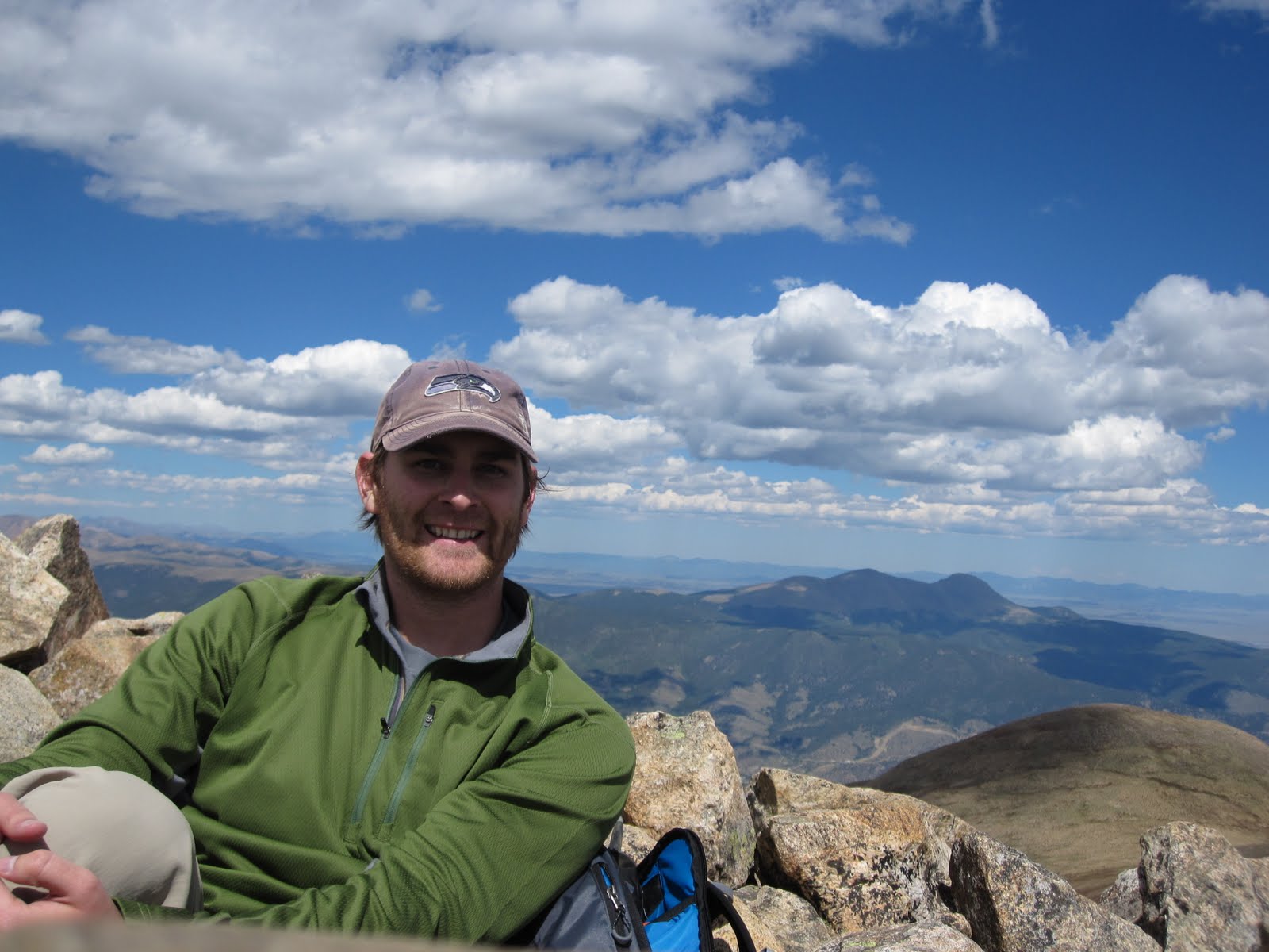
This ridge kept on going for what seemed like forever. From the saddle to the summit took me one hour and fifteen  minutes. I was happy to finally see the end and happier to get there. I had warmed up a bit by the time I reached the summit so I relaxed comfortably for about 25 minutes on top before going back down. An interesting "first" for me that's worth mentioning is that I never saw one human being on the entire trip. It kind of makes winter hiking even more appealing to me than spring and summer hiking. Anyway, I took a quick auto-timed photo with the awesome Crestones in the background and headed back for the car.


I can't wait to climb the Crestones. Such impressive mountains. The hike down was quick and uneventful. I had a great hike to kick off the Winter season. I'm looking forward to more winter hikes which I hope to be planning soon. This was my 11th 14er in 2010 and I'm hoping to hit 20 before 2011.

Notes to Self:
-get a headlamp
-get partners for winter hikes especially
-bring handwarmers to shove into my gloves

Cloud's Rest (Yosemite) 10/9/2010

Total Mileage: 12.8 miles
Elevation Gain: 3000 ft
Starting Point: Sunrise Lakes Trailhead


This picture was taken from google images. Cloud's Rest is right behind Half-Dome.

My wife and I had planned a trip to northern CA to visit some friends and spend a night in San Francisco where we used to live. We stayed a few nights with our friends, Rocia and Emerson. Emerson had mentioned possibly hiking Half-Dome on the Saturday we were there. I thought it was a great idea. About 3-4 days before leaving I was researching Half-Dome and come to find out that a permit is required to hike Half-Dome on the weekends. I thought I could just call up or apply online and get one but that was not the case. Suffice it to say, we could not get a permit so we would not be hiking Half-Dome. I solicited advice from my friends on 14ers.com and Cloud's Rest was suggested to me. It turned out to be a fantastic suggestion!

From Emerson's house it was about a four hour drive to the trailhead. Most of the day was spent discussing dentistry so you can imagine how wild it got. The huge granite slabs that make up these mountains are in stark contrast to what I'm used to hiking in Colorado. For me, it was awesome change of scenery and my first time hiking in Yosemite. I saw a beautiful peak called Mount Clark and I informed Emerson I would like to come back in the Spring to hike it.


Mount Clark is the prominent peak in the center.


The hike was moderate in difficulty and the trail seemed to follow the pattern of climbing then it would flatten out and repeat. Nearing the top, we began to see some of the awesome views of the granite faces.


The final pitch to the top:


After this last little hill we were on the summit with incredible views of the whole valley including Half-Dome.


Cloud's Rest summit. Elevation 9,926 feet.
Zooming in on Half Dome I could barely make out the people climbing the steep face.


We stayed on top for probably a solid hour. We shared the summit with about 10 people that day which I didn't think was too crowded for a Saturday. The views of Half Dome were awesome....almost as if I was holding it in my hand....


Emerson was better at staging this photo than I was.


Now for the posed shot.


While I know this isn't a "14er" I still thought it was an awesome hike. Definitely worthy of being shared. I hope to make it back to Yosemite soon. Big thanks to Emerson for suggesting we go hiking and for opening up his house to me and my family. Bros 4 eva!!

Wednesday, September 29, 2010

Castle and Conundrum Peaks 9/25/2010

Total Mileage: 12 miles
Elevation Gained: ~5000 feet
Staring Point: Castle Creek Trailhead


This was my favorite 14er hike to date! I set up this trip about a month ago with two friends of mine. They brought their wives with them, as I did, to Aspen. We spent Friday and Saturday night in a condo we rented for the two nights. We brought our kids along as well and it was time well spent with friends and family. Saturday morning the men set out for Castle Creek trailhead with aspirations of summiting Castle and Conundrum peaks. The day previous had been spent climbing Gray's and Torrey's Peaks as a little warm up for this hike. My friend Eric and I climbed together on both hikes and another mutual friend Joel joined us for the Aspen trip/hike. It was Joel's first 14er and he did awesome!

We knew the trailhead was the beginning of a 4WD trail that would shave a lot of mileage off our trip if we could make it up it. I only made it up about .5 miles before my 03' Passat hatchback had to pull over. I was hoping to make it up a mile but I didn't mind the extra mileage much. While hiking this 4WD portion, we were passed by multiple cars who were planning their start much further up the trail. The end of the 4WD trail puts you in Montezuma Basin and 12,800 feet. Cheating if you ask me, but to each their own. It reminded me a lot of the 4WD trail that most people skip when they hike Princeton. There is a scenic waterfall about 2 miles up the road.


We kept on hiking and cars kept on passing us. The hike was pretty uneventful until we made it to Montezuma Basin. From there we had a view of both mountains and we also ran into snow. Here's a view from the basin looking up.


Orange was our route up through the snow. Red shows how we got down. We suck at "Leave No Trace."
Once over this hump we had the last little climb to get to the top of Castle. Only it didn't feel little.


We had perfect weather which made for great views of the Maroon Bells, Snowmass, Capitol, and we could even see Uncompahgre and Wetterhorn far to the South. Of course, we could see our next project right in front us as well. Conundrum seemed much further away then it really was.


I honestly didn't know if my hiking team would be up for Conundrum. We were all pretty tired and worried about the way down. It looks much more daunting then it really is. Our route would be down to the saddle between Castle and Conundrum, up Conundrum, back to the saddle, and straight down from the saddle to Montezuma basin. I was excited to hear the group decide to press on after a 20 minute break on top of Castle Peak.

Admittedly, it is very deceiving to view the saddle from below and see a viable route down it. It appears as a straight rock face that would be too dangerous. The truth is that it is very doable and I would consider the west slope of Mount Columbia to be more dangerous. Reading multiple trip reports on 14ers.com proved to be very valuable. We were on top of Conundrum 45 minutes after leaving Castle. Much easier then we had anticipated. The descent was pretty easy.


The black arrow shows the point of our initial descent. From there, you can see where the snow meets the rock and that accurately delineates the path we took down into the basin. There's also a big scar across the snow pack that appears as a possible path from far away. It is a huge crevasse that reveals a large amount of glacial ice.

A closer look at my crevasse.
Here's the summit pics of Castle first and then Conundrum.


This next picture is taken from Castle looking back on the route up. Some of the hikers you can see climbing up give a little perspective of the steepness.


As shown before, we found some fun sledding to get down a significant portion of the mountain. Of course, by sledding I mean sliding on our butts and getting very wet. We got down to the basin fast and hiked back to the car which was parked about 3-3.5 miles from the basin. I think Joel's knees were hurting him. I hope he's feeling better. I should probably call him. Anyways, it was radical and I'd do that hike again in a heartbeat.

Funny story time. On top of Conundrum we asked a nice gentleman to take a picture of all three of us. He held out the camera and started to just take multiple pictures without skipping a beat in conversation. We weren't really ready or even aware he had taken any pictures yet. Then he said "I love digital" which I can only interpret to mean, "I like pushing the silver button 10 times and I bank on one turning out good." Fair enough. He did the same thing with Joel and Eric's cameras as well. I'm hoping they got a good one. So here's my one-out-of-ten diamond in the rough standout photo.


Classy
So all in all, about 12 miles roundtrip in about 9 hours start to finish. We headed back to Aspen and enjoyed dinner at the Hickory House. It was delicious and nutritious. Except probably not very nutritious. This made for my 9th and 10th 14er. Only 48 more to go. Then I'll be ready to do all the alternate routes on each 14er after that. Colorado rulez the school!

Notes to self:
-bring a change of socks

Monday, September 27, 2010

Gray's and Torrey's Peaks 9/24/2010

Total Mileage: 9 miles
Elevation Gained: 3600 feet
Starting Point: Steven's Gulch Trailhead


Torrey's Peak
 This hike was meant to be a warm-up for Castle and Conundrum peaks the next day. With short mileage and Class I terrain I didn't think this would be too draining of a hike. I got to hike this one with a buddy of mine named Eric. That would make it my first non-solo 14er. We got going around 7:00am and hiked about 4 miles to the summit of Gray's Peak. About halfway up we encountered some snow and by the top we were trudging through about 6-8 inches of fresh snow that had accumulated on the trail. Conditions were great for us. We had a little wind but clear skies the entire day. We shared the two peaks with a lot of other hikers. We rested for about 20 minutes on Gray's before heading over to Torrey's Peak.


On top of Gray's with Torrey's not too far off. 14,270 feet.
 We were on top of Torrey's about 45 minutes later and relaxed for another 20 minutes or so.

The following picture shows the standard route we took to Gray's summit.

Green is the route up and Blue would be the descent from Torrey's/Gray's saddle
As a side note about my pictures. I am using some trial software to make panoramics and it automatically writes that copywright info in the lower right hand corner. I'm not really concerned with claiming these pictures as my property. Please feel free to copy and distribute all you'd like.

We finished our hike around 1pm and headed back to pick up the wives and head to Aspen, CO for the weekend. We would be hiking Castle Peak and Conundrum while the girls do something else to be determined (but probably shopping). I was a little worried about Eric, that he may be too tired for more 14ers.


Notes to self:
-bring toilet paper
-drawing obscenities in the snow is immature but kind of funny also

Pikes Peak 9/18/2010

Total Mileage: 12.5 miles
Elevation Gained: 7800 feet
Starting Point: Barr Trail Trailhead


My Dad flew down from Spokane, WA to hike Pikes Peak with me! I had been looking forward to this trip since he called and arranged it. We had initially planned to only hike up and take the Cog Railway back down. The day before our hike a helicopter crashed on the mountain and I found out that the Cog may not be running the day of our hike. The Toll Road would also be closed down meaning our only descent option would be hiking the 12.5 miles down. We went ahead and planned to hike ourselves up and down the mountain and prepared for a 25 mile hike.

The picture quality is pretty bad here. My Dad and I both forgot to bring our cameras so I had to make due with just my phone. The picture above was taken about 4 miles into our 12.5 mile hike up Pikes Peak. We started up the trail at about 5:45am. It was dark for the first 45 minutes. We weren't using headlamps so we just had to adjust to it. By 6:20am it was getting lighter and visability wasn't an issue. The Barr Trail provides more elevation gain from trailhead to summit than any of the other 57 14ers. We started at about 6500 feet and ended at 14,110 feet.


At the halfway point there is a little cabin/campground called Barr Camp. It's essentially a campground with a bed and breakfast twist to it. You can purchase a campsite or indoor accomadations and at night a spaghetti dinner is served followed by a pancake breakfast in the morning. It also serves as a place to resupply. They sell Gatorade and other snacks. It was here we discovered that the Cog was running and we may not have to hike out if we didn't want to. This also meant that the summit house would be open.  A lot of people use this camp as a way to break up the hike into two days or more. So we took about a 20 minute break and kept on hiking up the trail.

This hike served as a source of redemption for me. About three months ago I decided I wanted to hike this trail with a friend of mine. I made it as far as Barr Camp and had to turn back. I'm embarrased looking back on that hike and realizing how underprepared I was. The guy who runs the camp with his wife told me I could hike 1.5 miles to a Cog stop and catch the train up and then back down. I had already purchased the tickets so I called ahead and told them I would be there to be picked up. So I still was able to enjoy the summit but I took no pictures because I felt unworthy. My friend hiking with me was in much better shape and drove much further than me to be there. I thought for sure he'd never hike with me again. This experience is what motivated me to get in shape and begin hiking 14,000 foot mountains. I started running after this and hiking the Manitou Incline twice a week. I lost about 15 lbs and I now consider myself an elite alpinist. So, this hike was fun to complete and it reminded me how I never want to be that out if shape again. Nobody likes a fat dentist.


This is my Dad just above treeline with the final 3 miles ahead of us. The altitude was definitely affecting him and we slowed our pace for the final few miles. We took frequent breaks and stayed well fed and hydrated. We arrived at the top at 2:00 pm on the dot.


We were very fortunate to find room on the Cog train going down the mountain. We had to wait in a line and ride in separate seats but we were sure relieved to not have to hike down the way we came. I was pleasantly surprised at how well my Dad did overall. You never know how someone is going to react to that kind of physical exertion at altitude. I hope to have him down for another soon!

Notes to Self:
-buy a headlamp
-don't forget my camera
-old man strength should not be underestimated

Friday, September 10, 2010

Mount Bierstadt 9/9/10

Roundtrip Mileage: 7 miles
Roundtrip Elevation: 5800 feet
Starting Point: Guanella Pass


This hike was one I wasn't planning on doing until about two days before I did it. My wonderful wife was great to let me spend the morning hiking. I had realized I had the day off and nothing to do. Climbing Mount Bierstadt was the obvious choice.

I arrived at the trailhead at about 6:45am after driving the final 13 miles over a half dirt/half asphalt road. The road was a bit deceiving as it was littered with significant potholes throughout. I was hiking towards Mount Bierstadt by 6:50am.

The initial portion of this hike runs through a swampy, wet field. Luckily, the trail leads to bridges that carry the hiker over the really wet muddy areas. If not for these bridges this trail would be much less desirable. While on the bridge I lost sight of the trail but I eventually found it again.


You can see from this picture that the fog was very low. This did not clear up until I was on my way down the mountain and nearly to my car. The fog rolled along the mountain side the entire morning. Winds were mild but still made for a cold hike up the mountain. Little lakes and streams were scattered throughout this meadow. Even with the fog it was a very pretty hike and I imagine I would enjoy this hike even more on a second trip given a clear day (maybe a good starter 14er for the ole' ball n' chain). About half way up the mountain the fog cleared for a moment to reveal the goal.


Normally, this is visable from the parking lot at the beginning of the trail but on this day, I only had about 5 minutes to soak in this view until the fog rolled back over it. This was the first time I've experienced a significant limit in visability while hiking. At times I couldn't see more than 20 feet in any direction. I was fortunate that route finding was not required on this hike. Towards the top, visability did not improve. I spent all of 10 minutes on the summit and decided I'd better start the descent. Being on top of a 14er isn't as exciting when you don't have the views you've worked so hard for. As I'm about to post this next picture of myself on the summit my wife informs me that I should explain why my face looks like I just went diarrhea in my pants. I have no explanation for this and I am posting this in spite of my wife's behest.


Arriving at the ridge leading to the final pitch the visability was at its worst. I snapped a photo on the way down looking back up the final pitch. There's a lone hiker somewhere in there.


It was also a first running into snow and ice. I started seeing snow at about 13,500 feet. This picture was at the summit.


It was 9:10am when I arrived at the summit. This was pretty good time for me. I zoomed down pretty fast as well. I didn't pass anybody on the way up and didn't see any other hikers at all until I was on the summit I was joined by another sole hiker. I saw plenty of hikers on the way down and secretly harbored ill feelings towards them because the fog started to clear almost as soon as I was about halfway down the mountain. I thought it unfair that I had woken up early and hiked the mountain and the "lazies" get to enjoy all the good views. I gave one hiker the "stinkeye" and I don't think he understood why. I may have whispered aloud, "Die in a fire."

Almost back at my car I turned around and the whole mountain was in view along with most of the route up.


It was 10:50 back at the car and I headed back for home. It was a quick hike and my 6th 14er. Next week I get to hike Pikes Peak with my Dad. I'm really looking forward to that even though I've already hiked it solo. It will be my first 14er with a hiking partner though which is another reason I'm looking forward to it. Most of my readers have asked me to make a post about it even though Pikes Peak has already been conquered. Since I'm all about making my readers happy, I'll do it.

Notes to Self:
-it's getting colder and while I wore gloves, I wish I had better ones
-find something to cover my ears
-work on my camera faces

Saturday, August 28, 2010

Mount Harvard and Mount Columbia 8/26/2010

Roundtrip Mileage: 15 miles
Roundtrip elevation: 12,200 ft.
Starting point: North Cottonwood Creek Trailhead


Mount Harvard is the third highest peak in Colorado and the highest peak I've climbed to date. I was very excited for this combo hike. I have heard that the standard western slope route up Columbia sucks a fatty so I figured if I did the loop I could avoid going up the west slope but would still come down it. I was very glad I had done that by the end of the day.

I left my house at 4am and arrived at the trailhead at 6:30am. I finally bought gloves which came in very handy (get it!). It was a cool morning and the first three miles went by quickly for me. This was my first time using trekking poles and I must say, I'm a believer. I still think they look really stupid, but they're as helpful as they are dorky. Right before treeline I hit a clearing and got my first glimpse of Mount Columbia.


A little further up Harvard came into view. As I stood taking this picture I realized that from this point I had three different views of three different 14ers.

To the north: Harvard


To the east: Columbia

And to the south: Yale

At this point I was in what's called the Horn Fork Basin. Apparently it's a popular place to camp for those attempting Harvard, Columbia, or both. I didn't see a single soul though. Pretty nice actually. From the top of Columbia I got a picture that shows much of the route from treeline to the summit of Harvard.

The red is a rough idea of the route I took.

Conditions were ideal for me. No clouds, no wind, no people. I've always been dead tired when I've reached the top of a 14er. After reaching Harvard's summit I felt fantastic and not anywhere close to out of gas. I had told myself that two things would turn me back at this point. If the weather was questionable or if I felt spent physically. Neither was the case so I decided to continue on to Columbia.

The most fun I've had on any 14er was climbing the last 30-40 feet to the summit of Harvard. It requires actual climbing and upper body strength to get there. And you know I've always been known for my upper body strength. Here's a pic of the final pitch.


Over those rocks and I had the summit all to myself.

No people so I had to rely on auto-timed pictures all day.

I took a video showing the 360 degree view from Harvard's summit.


So I stayed on top for about 20 minutes. I enjoyed the views, some food and some Gatorade and continued on to what would be the most taxing portion of the day. Hiking the traverse isn't as easy as just following the ridge all the way there. From Mount Harvard (14,420 ft) you drop down into a basin that is about 12,900 ft. How you get there and how far you drop in elevation is up to the hiker. Close to halfway between Harvard and Columbia there is an unnamed 13,000+ ft. peak. It is here where the hiker must choose to descend gently down this ridge increasing mileage or drop abruptly down a gully of loose rock cutting off a bit of the route. I chose the gully and deeply regretted it. Coming down the loose rock I found myself surfing rock slides for about 3-4 feet at every step. At one point I needed to slow myself down which I did very forcefully with one of my trekking poles. It stopped me but was snapped nearly in half in the process. It was unusable the rest of the day. In addition to that my knees took a pretty bad beating. If you choose the gully you don't need to drop down in elevation as much as long as you don't mind hiking on loose rock. I did mind though after coming down that gully. I continued down into the basin ending up where I would have ended up had I chosen the gentle descent. At the bottom I looked back to see the gully. The red indicates my route and the black is where I should have gone.


From the basin I could hike nearly the rest of the way on softer grassy terrain. My knees were bothering me so that's what I chose to do. Excluding the last 200-400 vertical feet to Columbia I was able to continue hiking on soft grass. It was slow-going but I felt no need to push myself knowing that the descent down Columbia would be coming soon. Close to the top of Columbia I saw a great view of Mount Princeton and Mount Yale together.

I actually had really good phone reception here so I called my wife to check in. (Brownie points!!)

I finally made it to the top at 2:30pm. It took 3 hours and 20 minutes just for the traverse. I had anticipated finshing that part in about 2 hours so I was surprised at how long it took. I ate some delicious PB&J dessert treat my wife made and headed down after taking this summit shot.

So I began the dreaded descent and I honestly expected the worse. Truth be told the gully I descended on the traverse was much worse. Also, much shorter to be fair. It wasn't so much the steepness down Columbia but the length that got to me after going down about 2/3 of the way. It just never ended. I passed a group of four climbing down that had climbed up the same way. Pretty impressive climb in my opinion. One that I do not plan on doing anytime soon. On the descent I grabbed one more shot of Harvard that also shows a bit of the steep slope I'm standing on.


One of the sloggiest slogs any slogger could ever slog. It sucked.

From the bottom of that western slope I was back in the Horn Fork Basin where I had been earlier that morning. I was about three miles from the trailhead and I enjoyed the leisurely stroll back to the car. Though by this time even a leisurely stroll was tough on my knees. I made good time back and arrived at my car at 5:25pm. A record 11 hour hike for me.

The worst decision of the day came on way home. I stopped at a gas station and bought a 44oz Mountain Dew so that I wouldn't get drowsy on the home (2 hour drive). I don't drink soda regularly let alone Mountain Dew. Mountain Dew was a bad choice. By the time I got home I was feeling mild symptoms of food poisoning. (Not that I think I had food poisoning. I just felt the same symptoms.) It lasted for about 6 hours and then by morning I was fine.

The next thing I have planned is in mid-September my Dad and I will hiking Pikes Peak. In late September I'm kicking around doing another combo. Maybe Castle Peak and Conundrum Peak. So to all my loyal readers, you will both have to wait until then for my next post. So sorry :(

Notes to Self:
-buy binoculars
-bring ibuprofen with me
-read trip reports over and over. No such thing as too familiar with the route