Wednesday, September 29, 2010

Castle and Conundrum Peaks 9/25/2010

Total Mileage: 12 miles
Elevation Gained: ~5000 feet
Staring Point: Castle Creek Trailhead


This was my favorite 14er hike to date! I set up this trip about a month ago with two friends of mine. They brought their wives with them, as I did, to Aspen. We spent Friday and Saturday night in a condo we rented for the two nights. We brought our kids along as well and it was time well spent with friends and family. Saturday morning the men set out for Castle Creek trailhead with aspirations of summiting Castle and Conundrum peaks. The day previous had been spent climbing Gray's and Torrey's Peaks as a little warm up for this hike. My friend Eric and I climbed together on both hikes and another mutual friend Joel joined us for the Aspen trip/hike. It was Joel's first 14er and he did awesome!

We knew the trailhead was the beginning of a 4WD trail that would shave a lot of mileage off our trip if we could make it up it. I only made it up about .5 miles before my 03' Passat hatchback had to pull over. I was hoping to make it up a mile but I didn't mind the extra mileage much. While hiking this 4WD portion, we were passed by multiple cars who were planning their start much further up the trail. The end of the 4WD trail puts you in Montezuma Basin and 12,800 feet. Cheating if you ask me, but to each their own. It reminded me a lot of the 4WD trail that most people skip when they hike Princeton. There is a scenic waterfall about 2 miles up the road.


We kept on hiking and cars kept on passing us. The hike was pretty uneventful until we made it to Montezuma Basin. From there we had a view of both mountains and we also ran into snow. Here's a view from the basin looking up.
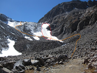

Orange was our route up through the snow. Red shows how we got down. We suck at "Leave No Trace."
Once over this hump we had the last little climb to get to the top of Castle. Only it didn't feel little.


We had perfect weather which made for great views of the Maroon Bells, Snowmass, Capitol, and we could even see Uncompahgre and Wetterhorn far to the South. Of course, we could see our next project right in front us as well. Conundrum seemed much further away then it really was.


I honestly didn't know if my hiking team would be up for Conundrum. We were all pretty tired and worried about the way down. It looks much more daunting then it really is. Our route would be down to the saddle between Castle and Conundrum, up Conundrum, back to the saddle, and straight down from the saddle to Montezuma basin. I was excited to hear the group decide to press on after a 20 minute break on top of Castle Peak.

Admittedly, it is very deceiving to view the saddle from below and see a viable route down it. It appears as a straight rock face that would be too dangerous. The truth is that it is very doable and I would consider the west slope of Mount Columbia to be more dangerous. Reading multiple trip reports on 14ers.com proved to be very valuable. We were on top of Conundrum 45 minutes after leaving Castle. Much easier then we had anticipated. The descent was pretty easy.


The black arrow shows the point of our initial descent. From there, you can see where the snow meets the rock and that accurately delineates the path we took down into the basin. There's also a big scar across the snow pack that appears as a possible path from far away. It is a huge crevasse that reveals a large amount of glacial ice.

A closer look at my crevasse.
Here's the summit pics of Castle first and then Conundrum.


This next picture is taken from Castle looking back on the route up. Some of the hikers you can see climbing up give a little perspective of the steepness.


As shown before, we found some fun sledding to get down a significant portion of the mountain. Of course, by sledding I mean sliding on our butts and getting very wet. We got down to the basin fast and hiked back to the car which was parked about 3-3.5 miles from the basin. I think Joel's knees were hurting him. I hope he's feeling better. I should probably call him. Anyways, it was radical and I'd do that hike again in a heartbeat.

Funny story time. On top of Conundrum we asked a nice gentleman to take a picture of all three of us. He held out the camera and started to just take multiple pictures without skipping a beat in conversation. We weren't really ready or even aware he had taken any pictures yet. Then he said "I love digital" which I can only interpret to mean, "I like pushing the silver button 10 times and I bank on one turning out good." Fair enough. He did the same thing with Joel and Eric's cameras as well. I'm hoping they got a good one. So here's my one-out-of-ten diamond in the rough standout photo.


Classy
So all in all, about 12 miles roundtrip in about 9 hours start to finish. We headed back to Aspen and enjoyed dinner at the Hickory House. It was delicious and nutritious. Except probably not very nutritious. This made for my 9th and 10th 14er. Only 48 more to go. Then I'll be ready to do all the alternate routes on each 14er after that. Colorado rulez the school!

Notes to self:
-bring a change of socks

Monday, September 27, 2010

Gray's and Torrey's Peaks 9/24/2010

Total Mileage: 9 miles
Elevation Gained: 3600 feet
Starting Point: Steven's Gulch Trailhead


Torrey's Peak
 This hike was meant to be a warm-up for Castle and Conundrum peaks the next day. With short mileage and Class I terrain I didn't think this would be too draining of a hike. I got to hike this one with a buddy of mine named Eric. That would make it my first non-solo 14er. We got going around 7:00am and hiked about 4 miles to the summit of Gray's Peak. About halfway up we encountered some snow and by the top we were trudging through about 6-8 inches of fresh snow that had accumulated on the trail. Conditions were great for us. We had a little wind but clear skies the entire day. We shared the two peaks with a lot of other hikers. We rested for about 20 minutes on Gray's before heading over to Torrey's Peak.


On top of Gray's with Torrey's not too far off. 14,270 feet.
 We were on top of Torrey's about 45 minutes later and relaxed for another 20 minutes or so.

The following picture shows the standard route we took to Gray's summit.

Green is the route up and Blue would be the descent from Torrey's/Gray's saddle
As a side note about my pictures. I am using some trial software to make panoramics and it automatically writes that copywright info in the lower right hand corner. I'm not really concerned with claiming these pictures as my property. Please feel free to copy and distribute all you'd like.

We finished our hike around 1pm and headed back to pick up the wives and head to Aspen, CO for the weekend. We would be hiking Castle Peak and Conundrum while the girls do something else to be determined (but probably shopping). I was a little worried about Eric, that he may be too tired for more 14ers.


Notes to self:
-bring toilet paper
-drawing obscenities in the snow is immature but kind of funny also

Pikes Peak 9/18/2010

Total Mileage: 12.5 miles
Elevation Gained: 7800 feet
Starting Point: Barr Trail Trailhead


My Dad flew down from Spokane, WA to hike Pikes Peak with me! I had been looking forward to this trip since he called and arranged it. We had initially planned to only hike up and take the Cog Railway back down. The day before our hike a helicopter crashed on the mountain and I found out that the Cog may not be running the day of our hike. The Toll Road would also be closed down meaning our only descent option would be hiking the 12.5 miles down. We went ahead and planned to hike ourselves up and down the mountain and prepared for a 25 mile hike.

The picture quality is pretty bad here. My Dad and I both forgot to bring our cameras so I had to make due with just my phone. The picture above was taken about 4 miles into our 12.5 mile hike up Pikes Peak. We started up the trail at about 5:45am. It was dark for the first 45 minutes. We weren't using headlamps so we just had to adjust to it. By 6:20am it was getting lighter and visability wasn't an issue. The Barr Trail provides more elevation gain from trailhead to summit than any of the other 57 14ers. We started at about 6500 feet and ended at 14,110 feet.


At the halfway point there is a little cabin/campground called Barr Camp. It's essentially a campground with a bed and breakfast twist to it. You can purchase a campsite or indoor accomadations and at night a spaghetti dinner is served followed by a pancake breakfast in the morning. It also serves as a place to resupply. They sell Gatorade and other snacks. It was here we discovered that the Cog was running and we may not have to hike out if we didn't want to. This also meant that the summit house would be open.  A lot of people use this camp as a way to break up the hike into two days or more. So we took about a 20 minute break and kept on hiking up the trail.

This hike served as a source of redemption for me. About three months ago I decided I wanted to hike this trail with a friend of mine. I made it as far as Barr Camp and had to turn back. I'm embarrased looking back on that hike and realizing how underprepared I was. The guy who runs the camp with his wife told me I could hike 1.5 miles to a Cog stop and catch the train up and then back down. I had already purchased the tickets so I called ahead and told them I would be there to be picked up. So I still was able to enjoy the summit but I took no pictures because I felt unworthy. My friend hiking with me was in much better shape and drove much further than me to be there. I thought for sure he'd never hike with me again. This experience is what motivated me to get in shape and begin hiking 14,000 foot mountains. I started running after this and hiking the Manitou Incline twice a week. I lost about 15 lbs and I now consider myself an elite alpinist. So, this hike was fun to complete and it reminded me how I never want to be that out if shape again. Nobody likes a fat dentist.


This is my Dad just above treeline with the final 3 miles ahead of us. The altitude was definitely affecting him and we slowed our pace for the final few miles. We took frequent breaks and stayed well fed and hydrated. We arrived at the top at 2:00 pm on the dot.


We were very fortunate to find room on the Cog train going down the mountain. We had to wait in a line and ride in separate seats but we were sure relieved to not have to hike down the way we came. I was pleasantly surprised at how well my Dad did overall. You never know how someone is going to react to that kind of physical exertion at altitude. I hope to have him down for another soon!

Notes to Self:
-buy a headlamp
-don't forget my camera
-old man strength should not be underestimated

Friday, September 10, 2010

Mount Bierstadt 9/9/10

Roundtrip Mileage: 7 miles
Roundtrip Elevation: 5800 feet
Starting Point: Guanella Pass


This hike was one I wasn't planning on doing until about two days before I did it. My wonderful wife was great to let me spend the morning hiking. I had realized I had the day off and nothing to do. Climbing Mount Bierstadt was the obvious choice.

I arrived at the trailhead at about 6:45am after driving the final 13 miles over a half dirt/half asphalt road. The road was a bit deceiving as it was littered with significant potholes throughout. I was hiking towards Mount Bierstadt by 6:50am.

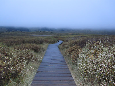
The initial portion of this hike runs through a swampy, wet field. Luckily, the trail leads to bridges that carry the hiker over the really wet muddy areas. If not for these bridges this trail would be much less desirable. While on the bridge I lost sight of the trail but I eventually found it again.


You can see from this picture that the fog was very low. This did not clear up until I was on my way down the mountain and nearly to my car. The fog rolled along the mountain side the entire morning. Winds were mild but still made for a cold hike up the mountain. Little lakes and streams were scattered throughout this meadow. Even with the fog it was a very pretty hike and I imagine I would enjoy this hike even more on a second trip given a clear day (maybe a good starter 14er for the ole' ball n' chain). About half way up the mountain the fog cleared for a moment to reveal the goal.


Normally, this is visable from the parking lot at the beginning of the trail but on this day, I only had about 5 minutes to soak in this view until the fog rolled back over it. This was the first time I've experienced a significant limit in visability while hiking. At times I couldn't see more than 20 feet in any direction. I was fortunate that route finding was not required on this hike. Towards the top, visability did not improve. I spent all of 10 minutes on the summit and decided I'd better start the descent. Being on top of a 14er isn't as exciting when you don't have the views you've worked so hard for. As I'm about to post this next picture of myself on the summit my wife informs me that I should explain why my face looks like I just went diarrhea in my pants. I have no explanation for this and I am posting this in spite of my wife's behest.


Arriving at the ridge leading to the final pitch the visability was at its worst. I snapped a photo on the way down looking back up the final pitch. There's a lone hiker somewhere in there.


It was also a first running into snow and ice. I started seeing snow at about 13,500 feet. This picture was at the summit.


It was 9:10am when I arrived at the summit. This was pretty good time for me. I zoomed down pretty fast as well. I didn't pass anybody on the way up and didn't see any other hikers at all until I was on the summit I was joined by another sole hiker. I saw plenty of hikers on the way down and secretly harbored ill feelings towards them because the fog started to clear almost as soon as I was about halfway down the mountain. I thought it unfair that I had woken up early and hiked the mountain and the "lazies" get to enjoy all the good views. I gave one hiker the "stinkeye" and I don't think he understood why. I may have whispered aloud, "Die in a fire."

Almost back at my car I turned around and the whole mountain was in view along with most of the route up.


It was 10:50 back at the car and I headed back for home. It was a quick hike and my 6th 14er. Next week I get to hike Pikes Peak with my Dad. I'm really looking forward to that even though I've already hiked it solo. It will be my first 14er with a hiking partner though which is another reason I'm looking forward to it. Most of my readers have asked me to make a post about it even though Pikes Peak has already been conquered. Since I'm all about making my readers happy, I'll do it.

Notes to Self:
-it's getting colder and while I wore gloves, I wish I had better ones
-find something to cover my ears
-work on my camera faces