Elevation Gained: ~5000 feet
Staring Point: Castle Creek Trailhead
This was my favorite 14er hike to date! I set up this trip about a month ago with two friends of mine. They brought their wives with them, as I did, to Aspen. We spent Friday and Saturday night in a condo we rented for the two nights. We brought our kids along as well and it was time well spent with friends and family. Saturday morning the men set out for Castle Creek trailhead with aspirations of summiting Castle and Conundrum peaks. The day previous had been spent climbing Gray's and Torrey's Peaks as a little warm up for this hike. My friend Eric and I climbed together on both hikes and another mutual friend Joel joined us for the Aspen trip/hike. It was Joel's first 14er and he did awesome!
We knew the trailhead was the beginning of a 4WD trail that would shave a lot of mileage off our trip if we could make it up it. I only made it up about .5 miles before my 03' Passat hatchback had to pull over. I was hoping to make it up a mile but I didn't mind the extra mileage much. While hiking this 4WD portion, we were passed by multiple cars who were planning their start much further up the trail. The end of the 4WD trail puts you in Montezuma Basin and 12,800 feet. Cheating if you ask me, but to each their own. It reminded me a lot of the 4WD trail that most people skip when they hike Princeton. There is a scenic waterfall about 2 miles up the road.
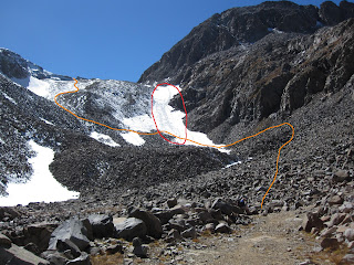
We kept on hiking and cars kept on passing us. The hike was pretty uneventful until we made it to Montezuma Basin. From there we had a view of both mountains and we also ran into snow. Here's a view from the basin looking up.
 |
| Orange was our route up through the snow. Red shows how we got down. We suck at "Leave No Trace." |
We had perfect weather which made for great views of the Maroon Bells, Snowmass, Capitol, and we could even see Uncompahgre and Wetterhorn far to the South. Of course, we could see our next project right in front us as well. Conundrum seemed much further away then it really was.
I honestly didn't know if my hiking team would be up for Conundrum. We were all pretty tired and worried about the way down. It looks much more daunting then it really is. Our route would be down to the saddle between Castle and Conundrum, up Conundrum, back to the saddle, and straight down from the saddle to Montezuma basin. I was excited to hear the group decide to press on after a 20 minute break on top of Castle Peak.
Admittedly, it is very deceiving to view the saddle from below and see a viable route down it. It appears as a straight rock face that would be too dangerous. The truth is that it is very doable and I would consider the west slope of Mount Columbia to be more dangerous. Reading multiple trip reports on 14ers.com proved to be very valuable. We were on top of Conundrum 45 minutes after leaving Castle. Much easier then we had anticipated. The descent was pretty easy.
The black arrow shows the point of our initial descent. From there, you can see where the snow meets the rock and that accurately delineates the path we took down into the basin. There's also a big scar across the snow pack that appears as a possible path from far away. It is a huge crevasse that reveals a large amount of glacial ice.
 |
| A closer look at my crevasse. |
This next picture is taken from Castle looking back on the route up. Some of the hikers you can see climbing up give a little perspective of the steepness.
As shown before, we found some fun sledding to get down a significant portion of the mountain. Of course, by sledding I mean sliding on our butts and getting very wet. We got down to the basin fast and hiked back to the car which was parked about 3-3.5 miles from the basin. I think Joel's knees were hurting him. I hope he's feeling better. I should probably call him. Anyways, it was radical and I'd do that hike again in a heartbeat.
Funny story time. On top of Conundrum we asked a nice gentleman to take a picture of all three of us. He held out the camera and started to just take multiple pictures without skipping a beat in conversation. We weren't really ready or even aware he had taken any pictures yet. Then he said "I love digital" which I can only interpret to mean, "I like pushing the silver button 10 times and I bank on one turning out good." Fair enough. He did the same thing with Joel and Eric's cameras as well. I'm hoping they got a good one. So here's my one-out-of-ten diamond in the rough standout photo.
 |
| Classy |
Notes to self:
-bring a change of socks


Love it! We will definitely have to plan out a day trip when we drive through CO. Just remember, I am coming from sea level, so I may struggle with the thin air.
ReplyDelete